Friday, January 29, 2010

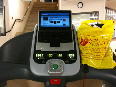
Treadmill Computing

Walking the treadmill
while using a laptop isn't
exactly mobile computing.

But it's the same basic idea...

Give us a device large enough to use at arms length.

Yet powerful and small enough to
be practical.

I was stoked to see Apple release the iPad. I'd been dreaming of a touch tablet for years.


Unfortunately, AT&T's shit network will make it unusable inside the gym.
Don't believe me? Review of Nokia Booklet 3G: LINK HERE


Behold my 17" laptop.


Not exactly an iPhone (which btw, gets no signal in the gym).


I've been traveling for the past year.


A lot of different treadmills...


A lot of different gyms...


And hotels.


I even tried a netbook. Click HERE for Review


Balancing
a laptop on a treadmill usually depends on the handlebars.


Unfortunately, the newer models are going for that sleek look.


Occasionally, I've been able to jury rig treadmills to hold my laptop.


I'd long had the idea for a more universal solution.


A sort of harness...


As for the internet, I use Verizon.


Their mobile broadband coverage is excellent.


Even inside gyms, sorry AT&T.

Thursday, January 28, 2010

Zephyr Cove


From Cave Rock
I continued south.

I made one last
stop in Nevada.

Zephyr Cove has a wide sandy beach.

It also offers commercial day-cruises around Lake Tahoe.


With camping and an RV park, Zephyr Cove stands in contrast to its neighbor.


South Lake Tahoe marks the state line between Nevada & California.


I was hoping to take the aerial tram there.


But a snowstorm was expected to blanket the Sierra Nevada Mountains.

Cave Rock


After Sand Harbor,
I left the shore of Lake Tahoe.

Hwy 28 cuts inland; then back to the lake.

I passed through a tunnel; almost missing the turn-off to Cave Rock State Park.


This tunnel was blasted through a huge chunk of basalt.


Don't be fooled by exposed volcanic rock, such as the basalt of Cave Rock.


Lake Tahoe
was formed by normal faulting and is not a caldera.


Cave Rock was popular for rock climbing. Especially in winter, when other areas were covered in snow.


I was told climbing Cave Rock is no longer permitted. Something to do with Native American sacred beliefs.


These stop-offs on the Nevada side of Hwy 28 are mostly part of Lake Tahoe-Nevada State Park.


These designations are interesting. Lake Tahoe is split between two states: Nevada & California.


And, among five counties: Placer, El Dorado, Douglas, Washoe, & Carson City.

Why does Carson City claim a slice of Lake Tahoe?

It's city limits
have bizarre panhandle; stretching through the mountains and into the lake...

Wednesday, January 27, 2010

Sand Harbor


I continued south from Memorial Point
to Sand Harbor.


Sand Harbor State Park

is a small peninsula on the east shore of Lake Tahoe.


Hands-down, this is the best beach on the Nevada side of the lake.


[This was actually my second visit to Sand Harbor.


While driving the Owens Valley in March 2009, I was forced to take a major detour.


I naively thought the Tioga Pass into Yosemite would be open.


A ranger at Manzanar National Historic Site advised me otherwise.


I crossed the Sierras via Rt. 80, in a blizzard!]


Sand Harbor State Park has a long boardwalk with several interpretive plaques. This makes it easy to learn about the natural history of Lake Tahoe.


Lake Tahoe reflects the color of the sky. It's blueness depends on how clear or cloudy that day happens to be.


Sand Harbor has a cove.


And a broad beach, as well.


Large boulders tumble from the beach to the water.


Endless nooks and crannies beg exploration.


Tuesday, January 26, 2010

Memorial Point


I continued driving south on the Nevada side of Lake Tahoe.

Hwy 28 hugs the shore. The mountains rise sharply.

Through the trees I could catch glimpses of Lake Tahoe shimmering in the afternoon sun.


I stopped at Memorial Point; one of only a few areas with shore access along Hwy 28.


Kiosks helped situate my position. And provided historical information on Lake Tahoe.


I walked a short trail down to the shore.


Lake Tahoe is known for it's lack of turbidity.


The water is exceptionally clear.


Native Americans have been coming to Tahoe's shores for generations.


I found countless grinding holes used for preparing acorn meal.

Hidden Beach


A Tahoe local told me about a place called Hidden Beach.

I did my best to look for it as I left Incline Village.

Heading south on Hwy 28, it was supposed to be at the edge of town.

I must have passed it. Enjoy this short video of Lake Tahoe:

Wednesday, January 20, 2010

Tahoe Meadows


I asked around Incline Village about good hiking.

Tahoe Meadows and Mt. Rose was suggested.

The vista point on Rt. 431 is worth a stop.


I parked off the highway just past the Mount Rose summit.


Next, found the Tahoe Rim Trailhead.


Right away I had a wildlife sighting. Strange for a Great Horned Owl to be out in daylight:


A young sapling basked in the morning light:


There was a mysterious set of tracks. Later determined to be a hare.


The Tahoe Rim Trail passes through a meadow:


Followed by switchbacks up a hillside of Manzanita:


It was a clear day.

The view from the summit was clear across Lake Tahoe.

I could see all the way to California.


I relaxed on the boulders and took in the view.


This was a good spot for a picnic.


And posing for panoramic photos.